GIS Expertise at Turku Helps Tanzanians in the Development of Their Country
There is a map of Tanzania on the computer screen. Zahor K Zahor already utilizes the information on the map in an expert manner. At the University of Dar es Salaam, he used geographical information that was collected with the help of the locals in his doctoral thesis which was supervised by Senior Lecturer in Geography Niina Käyhkö of the University of Turku.
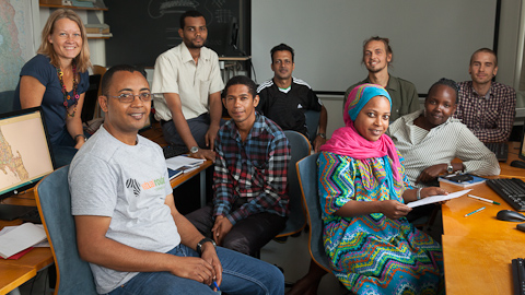
Niina Käyhkö (left.) and Joni Koskinen (3rd on the right) teach Andrew Ferdinands (2nd on the left), Mohammed Badruddin Mussa, Zahor K Zahor, Masoud S. Hemed, Faraja D. Namkesa and Pilly Silvano to utilise geographical information systems. Vesa Arki, a student of geography, is leaving for a three-month internship in Tanzania, where he can use his expertise in geographical information systems in local urban and regional planning.
Now Zahor and the five other Tanzanians, who are all been part of development projects funded by Finland, are in Turku to learn more about the use of Geographical information systems (GIS).
Niina Käyhkö describes in a few sentences why geographical information system education and research are necessary. Still in the 1980s, GIS was only available for few experts such as land surveyors. The field started to quickly digitalise in the 90s and now in 2010 the open data has provided an access to GIS for the researchers as well as for the citizens and the number of businesses in the field is growing. An increasing amount of the operations of the modern society are based on real time geographical information – from mobile applications to planning the placement of new schools, healthcare or a quickest route for an ambulance.
– GIS education is clearly growing globally. More and more software interfaces are based on maps and people have to know how to use and develop them. Our goal is that GIS and geospatial analysis would become one of the University’s methodological areas of strength, says Käyhkö, who is working as a Senior Lecturer in Geoinformatics at the University of Turku.
One step towards this goal is strong international cooperation. An example is the cooperation between the Department of Geography and Tanzanian researchers and government which began in 2003. At first, the Finnish researchers mainly worked in Zanzibar, but later on the cooperation has expanded to the Tanzanian mainland and become more reciprocal. Käyhkö is ready to bury the term “aid to developing countries” and talks about developing and learning together.
– We research, learn and develop together. The strength of GIS is that its use is applicable and that functional applications require solutions that fit the surroundings. In the education, we strive to teach geographical information system data and software with both Finnish and Tanzanian materials as well as with the challenges that the two very different environments present to the applications. This way the knowhow of each participant becomes more diverse, says Käyhkö.
Education as an Export
With HEI-ICI funding, which is directed to collaboration projects between higher education institutions in Finland and developing countries, the researchers from the University of Turku have the possibility to educate their Tanzanian colleagues in the use of GIS. As a bonus, experts working in the other Finish-Tanzanian development projects (SMOLE, PFP) came for training in Turku. By combining resources flexibly, the network of GIS experts in Tanzania will grow stronger.
The University of Turku will also benefit from the cooperation.
– We learn from real problems and challenges. We see concretely to what kind of social context GIS is linked to and what are the special challenges for the use of GIS in Tanzania. Our goal is to educate key experts who will in their turn educate even more experts. This way we can test, standardize and expand GIS education and develop it into an export model, says Käyhkö.
Zahor K Zahor tells that the Tanzanians will begin their own GIS education for experts and trainers already this autumn. In addition to him, two other PhD students from the University of Dar es Salaam came to learn about GIS.
–We have to start everything at grass roots level, says Zahor.
What also helps the cooperation is that GIS research uses open data and software.
GIS to Help in Erasing Poverty
In Tanzania, the GIS applications are still new but their significance is well understood. One example is the new SUSLAND research project led by Niina Käyhkö in Finland which received 390,000 euro development research funding from the Academy of Finland at the beginning of the summer. The project researches the sustainability and structure-function-benefit chains in the landscape systems of the Tanzanian Southern Highlands, which is mapped with GIS and the help and involvement of the locals.
The research project of the University of Turku will for its part support the goals of Private Forestry Programme (PFP) funded by the Ministry of Foreign Affairs Finland and the Tanzanian Government. The goal of the development project is to create a better living environment to the Tanzanian Southern Highlands by utilising geographical information systems.
– The area is very poor and we strive to develop the conditions by planting forest and with better planning for the land use. To avoid the situation where one person plants a tree and the next day someone digs it up saying this is a field, we have to draw up a plan for the area, describes GIS expert Andrew Ferdinands, who is working in the project.
At the University of Turku, also Jyrki Luukkanen’s project Green Economy Transitions in the Least Developed Countries received the development research funding.
Text and photo: Erja Hyytiäinen
Translation: Mari Ratia