Tutkimus maantieteen ja geologian laitoksella
”Maailma pintaa syvemmältä” antaa hyvän käsityksen laajasta tutkimuskentästämme sekä tavoitteestamme ymmärtää erilaisten ilmiöiden taustalla vaikuttavia mekanismeja.
Maantieteen keskeiset tutkimusalat
- Innovaatioympäristöt ja kaupunkimaantiede
- Soveltava paikkatietotutkimus
- Jokiympäristöt ja rannikkomeret
- Ympäristön dynamiikka ja globaalimuutos
Geologian keskeiset tutkimusalat
- Fennoskandian geologia
- Sedimentologia ja historialliset ympäristömuutokset
Tutkimusryhmät
The Crust Formation Group at the University of Turku studies the petrology and geochemistry of Precambrian plutonic rocks. We use geochemical and isotopic methods to explore rocks origins, formation settings, and the evolution of continental crust. Our research also focuses on ore-forming processes and improving analytical precision for critical minerals (Co, P, Li), base metals, and precious metals essential to crustal development.
DIDAIhub is a community platform and a catalyst of innovative research and learning solutions with global impacts at the University of Turku. The community thrives from system-level and transformative research, which aims to turn data, tools, skills and competences into actionable solutions for sustainable and climate resilient ecosystems and life all over the world. We approach global sustainability challenges with an inclusive and transformative mind-set, combining local talent and engagement with open data, digital technologies and citizen engagement. The good practices and innovative solutions gathered to DIDAIhub have been developed and piloted together with our long-lasting academic and societal partners and include solutions such as Geospatial Challenge Camp Finland, Tanzania Resilience Academy, Participatory Village Land Use Planning and Climate Risk Database. Welcome to explore and join our community!
Economic Geography research group conducts high quality research that has both academic significance as well as applications. The research focuses both on academic (basic) and applied research. Our research focuses on the spatial dimensions of logistics, maritime systems, and urban-regional development. Operating as a hybrid model—both centralized and networked—the group includes researchers based in cities of Turku, Helsinki, and Kotka, enabling broad collaboration across institutions and regions. Our research is interdisciplinary, integrating geography with economics, logistics, and policy studies. The group maintains strong partnerships with domestic institutions as well as international collaborators. Our group is an active member of Kotka Maritime Research network. The group’s dynamic structure and broad collaborations position it at the forefront of economic geography research in Finland.
The Fluvial and Coastal Research Group (FCRG) studies fluvial and coastal processes and environments. Our research focuses on past, present, and future river and coastal dynamics. We are particularly interested in how riverine and coastal environments change and how human interactions with these systems influence natural processes, leading to changes in, for example, flow regimes, erosion–sedimentation processes, and physicochemical water dynamics.
Our research group is dedicated to exploring the geoenergy potential of crystalline cratons, aiming to expand geothermal resource development beyond conventional magmatic systems. We focus on the geological characterization of the Earth's subsurface to advance the understanding of heat and fluid transfer within the upper crystalline crust. Our investigations range from conventional to unconventional geothermal systems and also explore subsurface reservoirs suitable for carbon sequestration, as well as the formation of critical energy-related elements such as lithium and hydrogen found in geothermal brines.
Current projects include Deep-HEAT-Flows (https://deep-heat-flows.voog.com/), funded by the Research Council of Finland, which investigates the natural processes that create deep crystalline reservoirs. Another key project is High-Resolution Chemostratigraphy of the World’s Deepest Geothermal Well: Implications for Faulted Lithologies and Subsurface Exploration in Finnish Crystalline Basement Settings, funded by the Renlund Foundation.
By enhancing our understanding of subsurface processes, we contribute to the sustainable development of geothermal energy and critical mineral extraction, supporting the transition to cleaner energy solutions.
Resilience Academy (RA) is a university-led partnership program focused on boosting digital skills, employment, and climate risk management for African youth in urban areas. By engaging local students and communities, RA fosters a digital ecosystem where citizen-generated geospatial data supports better urban climate resilience. RA is built on four main services: (1) a mass internship model enabling students, communities, companies, and NGOs to collaboratively collect and share digital geospatial data, addressing data gaps in underserved societies; (2) the Climate Risk Database (CRD), an open-access platform (Geonode) where all collected data is licensed, shared, and reused to inform decision-making and teach data skills; (3) micro-sized e-learning modules providing practical, accessible training to students and local universities, overcoming traditional shortages of learning materials and supporting global skills transfer; and (4) a research and innovation network serving as a “living lab” for developing and scaling digital data solutions to urban climate challenges. The Academy’s approach develops youth digital and employment skills, stimulates the local data economy, and improves climate risk management—helping communities and residents adapt to the impacts of rapid urbanization and climate change. RA thus achieves mutually beneficial outcomes in employment, environmental sustainability, and community resilience.
The Sediments and Environmental Change (SENCE) research group uses aquatic sedimentary archives to address diverse topics from past to on-going climate and environmental change. The sediment archives we investigate reach thousands of years back in time and have recorded information on Earth history all the way to present day.
Despite the long timescales, our research uses very high – even seasonal – resolution. In addition to the sedimentary archives, we use modelling and monitoring approaches to address timely topics such as impacts of climate change and anthropogenic land use on the natural environment, the consequences of which include decreasing water quality and eutrophication, as well as emerging pollutants in lacustrine and coastal systems. Our diverse research activities include seeking solutions to efficiently measure the rate of microplastic accumulation in water bodies to answer the global call for improved monitoring and alleviation of plastic pollution. We also address the need for well-dated environmental archives by further developing geochronological methods, for example, we work to refine the Northern European tephra framework through investigations of annually laminated sediments.
Webpage: https://sites.utu.fi/sence/
Ryhmä koostuu rakennegeologian osaajista, joiden tavoitteena on ymmärtää Fennoskandian kallioperän kehitystä yhdistämällä moderneja menetelmiä perinteiseen kenttätutkimukseen.
Sustainable Landscape Systems Research Group integrates social, ecological and technological domains to study human-nature interactions in multifunctional landscapes. Research has a strong place-based approach, thorough the application of geospatial, earth observation, participatory mapping, and qualitative approaches.
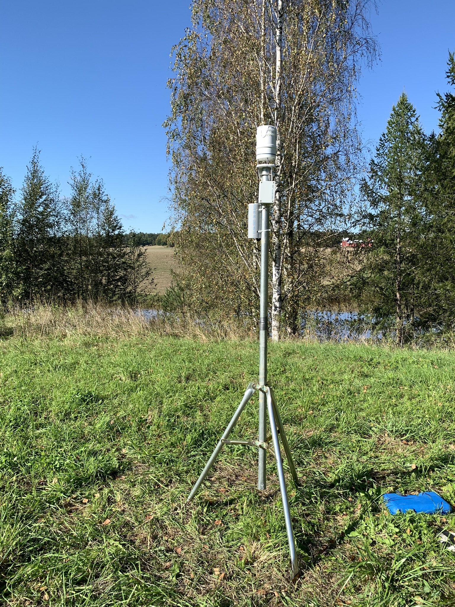
Turku Urban Climate Research Group (TURCLIM) conducts research on spatio-temporal patterns of urban climate with the aid of permanent weather data collection system and GIS data. We aim to increase our understanding concerning climatological variations in and around the city of Turku, both by providing long-term climatological data and by exploring it in advanced spatial analysis and modeling environments.
More specifically, our aim is to:
• provide long-term temperature and relative humidity data from a stable network of ca. 80 stations;
• provide better understanding concerning the climate in Turku and its surroundings;
• apply the generated understanding in relation to the practical needs of urban planning and maintenance;
• contribute to the overall understanding of urban climatology under the (hemi)boreal climatological realm, and
• stimulate and enhance scientific research and education on climatology in the University of Turku, with geographical orientation
Projektit
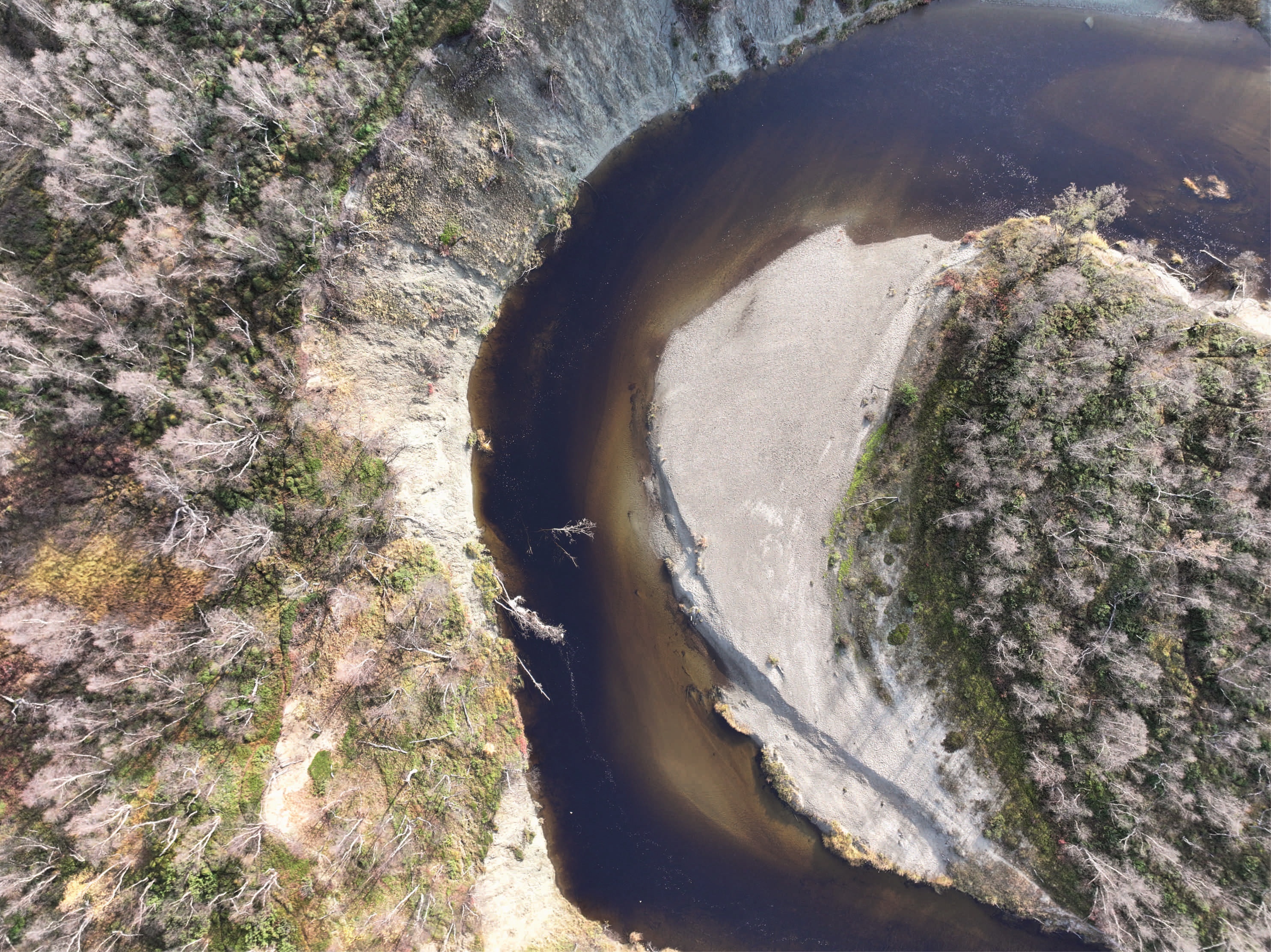
- Ihmistoiminnan ja ilmastonmuutoksen vaikutukset menaderoivien jokien dynamiikkaan (AnthroCliMocs)
- AnthroCliMocs on Akatemiatutkijahanke, jonka tavoitteena on tutkia, miten ilmastonmuutos ja ihmistoiminnan aiheuttamat paineet vaikuttavat meanderoivien jokien dynamiikkaan yhdistämällä edistyneitä 3D-kenttähavaintoja, kaukokartoitusta ja laskennallista mallinnusta.
- Rahoittaja: Suomen Akatemia
- Avainsanat: Geoinformatiikka; Ihmisvaikutus; Ilmastonmuutos; Jokiprosessit; Kaukokartoitus; Laskennallinen mallinnus; Meanderointi, Vesienhoito; Uoman evoluutio; Tulevaisuuden skenaariot
Yhteyshenkilö:
Elina Kasvi
Our goal at DIWA is to secure water for people and ecosystems by implementing integrated and sustainable practices. We aim to become a top-tier water research cluster and innovation ecosystem that generates high-impact research outputs, input to policy development and innovations arising from the next industrial revolution. DIWA aims to cultivate a new generation of water sector leaders skilled to address urgent water related challenges.
Innovative solutions provided by the DIWA Flagship are crucial in manifesting the value of water, improving its management and securing a sustainable future for people and ecosystems worldwide
The solutions provided by the DIWA Flagship are urgently needed as water is a critical natural resource globally. Climate change, biodiversity loss, environmental pollution and water scarcity require additional investments that will increase the value of water.
DIWA projects:
Digital Waters doctoral education pilot responds to the growing need for doctoral-level experts in the Digital Waters Flagship area.
The doctoral education pilot focuses on the Flagship research area of complex interactions and responses in the hydro-, atmo-, and cryosphere.
The main objective of the FLORES project is to study a genetic link between orogenic gold deposits and LCT pegmatites and to build a geodynamic model for the related fluid activity within Svecofennian Orogen at around 1.80 Ga.
HuRiIA is a co-research project conducted with Iraqi women living in Finland. It seeks to uncover and give recognition and visibility to 50 Iraqi women’s creative responses and resistance as they pursue their rights in Finland. While we aim to scrutinise their adaptation and creation of new spatial practices to access their fundamental human rights, navigating through multiple normative frameworks shaped by both Finnish and Iraqi contexts, the tasks are meant to support creative self-expression, strengthen their narratives, and acts of resistance.
The HuRiIA project aims to achieve three key objectives: (1) To explore the impact of the interactions between various spaces—such as countries, homes, streets, restaurants, the internet, and personal bodies—and normative orders—including state law, religious norms, tribal law, and family rules—on the lives and access to rights of Iraqi women in Finland. (2) To develop creative scientific methods for investigating and presenting the lived experiences and challenges faced by these women across physical, digital, and imaginary spaces. (3) To create a significant societal impact by amplifying the voices of Iraqi women, engaging actively in social debates, and producing educational materials for seminars aimed at stakeholders monitoring fundamental rights in Finland and Europe.
MUST (Murtoo Scientists) and collaborating researchers from Sweden have identified a subglacial landform previously unknown to science. This landform, the murtoo, has a unique triangular shape and dimensions only detectable through LiDAR-based digital elevation models. Murtoos are not predicted by existing theories of subglacial landforms and, therefore, understanding their formation is essential to better constrain their role in glacial hydrology and ice-sheet dynamics.
The Murtoos and Past Glacial Environments Research Group aims to bridge the gap between channelized and distributed drainage systems in the current theory of subglacial hydrology and related modelling approaches. Our research encompasses the broader meltwater drainage system of the past Fennoscandian Ice Sheet (FIS), with an emphasis on the role of subglacial meltwater corridors, subglacial lakes and supraglacial meltwater outburst imprints (water blisters). Other research themes include studies of glacial geomorphology, such as the De Geer moraines, eskers and ice-marginal complexes, for better understanding of sediment deposition and ice-margin behavior under FIS glaciation-deglaciation cycles. Ice-marginal depositional environments and related processes, as well as their influence on the hydrogeology of the groundwater reservoirs, are studied in collaboration with the Geological Survey of Finland and the Digital Waters (DIWA) flagship of the University of Turku. Our research utilizes LiDAR-based datasets and sedimentological fieldwork supplemented with geophysical investigations via Ground Penetrating Radar and high-resolution reflection seismic surveys. Together with our well-established national and international collaborators, we conduct high-quality research on past glacial environments and how they respond to climatic change.
Webpage: sites.utu.fi/reward
- Networked Environmental Monitoring and Evaluation System for Intelligent Surveillance (NEMESIS)
- Koordinaattori: Turun Ammattikorkeakoulu, partnerit: Turun Yliopisto ja Åbo Akademi
- NEMESIS-tutkimusinfrastruktuuri tuottaa Saaristomeren rannikko- ja merialueilta sekä niiden valuma-alueelta ympäristön tilaa ja merellistä turvallisuutta koskevaa aineistoa, joka mahdollistaa valuma-alueiden ja rannikkovesien tilaan, rannikko- ja vesiekologiaan sekä merialueiden turvallisuuteen liittyvän tutkimuksen.
- Rahoittaja: Suomen Akatemia
- Avainsanat: Saaristomeri; Ympäristön seuranta; Valuma-alue; Vesiensuojelu; Vedenlaatu
Yhteyshenkilö:
Elina Kasvi
- Horizon Europe -rahoitteisen RESIST-hankkeen (Regions for Climate Change Resilience through Innovation, Science and Technology) tavoitteena on vauhdittaa ilmastonmuutokseen sopeutumista ja ilmastokestävyyttä eri puolilla Eurooppaa. Hankkeessa testataan ilmastonmuutokseen sopeutumisen polkuja useilla eurooppalaisilla alueilla, ja Lounais-Suomessa painopiste on luontopohjaisissa ratkaisuissa vesienhallintaan kaupunki-, maaseutu- ja teollisuusympäristöissä, vastaten muun muassa talvitulvien, kesäkuivuuden, maaperän eroosion ja ravinteiden vesistöihin huuhtoutumisen haasteisiin.
- https://resist-project.eu/
- Rahoittaja: Horizon Europe
- Avainsanat: Ilmastonmuutokseen sopeutuminen; Luontopohjaiset ratkaisut; Vesienhallinta; Vedenpidätys; Vesiensuojelu
Yhteyshenkilö:
Elina Kasvi
Tutkimuksen tavoitteena on tutkia muovien kiertotaloutta, arvoketjua ja kierrätykseen liittyviä liiketoimintamalleja maantieteellisestä näkökulmasta. Tutkimuksen empiirinen osa kohdistuu kasvi- ja puutarhatuotannossa käytettäviin muovimateriaaleihin ja niiden käsittelyyn. Millä edellytyksillä näitä materiaaleja voidaan muuttaa jätteistä uusioraaka-aineiksi ja korvata muilla materiaaleilla tai viljelytekniikoilla? Mitä toimia tämä muutos edellyttää? Valotamme muovien arvoketjua, pyrimme tunnistamaan muovimateriaalien keräyksen ja talteenoton sekä kierrätyksen ongelmakohtia.
Projekti alkoi vuonna 2022 ja on käynnissä vuoden 2029 loppuun.
Verkkosivut: https://sites.utu.fi/plastlife/
Lisätietoa: https://www.materiaalitkiertoon.fi/en-US/PlastLIFE